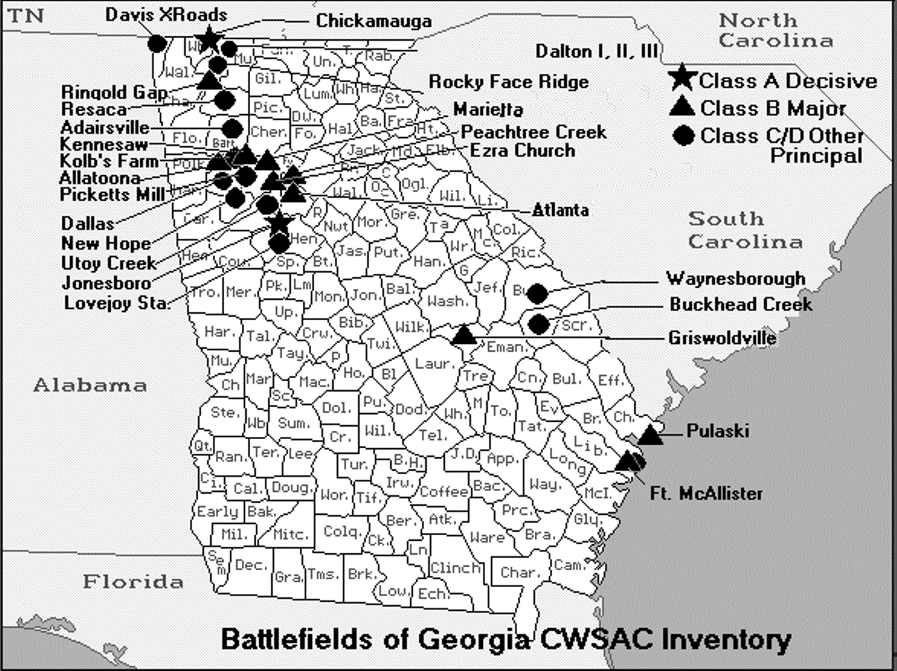

Click for Georgia Battlefields Map
![]()
![]()
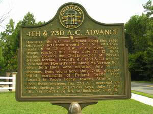
One of the many markers located throughout Georgia. This one marks the advance of the Federal 4th & 23d Army Corps. The marker is numbered GHM 060-15 and is located in Fulton County at Old Powers Ferry Rd and Mt Vernon Highway, Sandy Springs
[33°54'20N, 84°25'00W]
Visit us on Facebook

Page updated August 5, 2020

© Civil War Markers 2005-2010 All rights reserved.
To contact us:
E-mail: pictures@civilwarmarkers.com
Georgia Civil War Markers
Georgia has almost 2,600 historical markers covering the state, a total only exceeded by Texas (11,000) and New York (2,800). Of the 2,600 markers, one guess is that some 950 are related to the Civil War. Ed Jackson says "Coming up with a complete list of all Georgia historical markers related to the Civil War is a bit subjective--and in any event will almost require a reading of the text of each marker." The listings that follow have been extracted from the extensive listings located at the GeorgiaInfo WEB site. GeorgiaInfo was created in 1996 by Ed Jackson, and is assisted by Charles Pou who maintains the site. For 12 years the Carl Vinson Institute of Government hosted GeorgiaInfo but as of July 1, 2008 they have been hosted by GALILEO and the Digital Library of Georgia. My listings have been pruned to reflect only the locations of Civil War related markers and do not cover all of the counties within Georgia. Visit the GeorgiaInfo site for a full history and explanation of the Georgia Historical Markers program.
The historical markers originally listed on the Carl Vinson Institute of Government, University of Georgia WEB site were initially compiled by David Seibert of Sandy Springs based on ongoing work over the past three decades in collaboration with Ken Boyd, Harvey Gambrell, and Billy Townsend -- as well as earlier work by Carroll P. Scruggs, Ken Carlsrud, the Georgia Department of Natural Resources, and others. During this time, David, Ken, and Harvey have driven across the state on numerous occasions attempting to verify the existence and location of markers on the list.
The county index lists photographs from the GeorgiaInfo WEB site except those with a date (0/00/00) or those with a date and GPS information (0/00/00) [00°00.00N, 00°00.00W]. Listings marked with those keys have personally been visited and photographed by Donald R. Hogan, Milton, GA. Many of the photographs on the GeorgiaInfo site are attributed to Ed Jackson, Charlie Geiger and other "marker nuts" as we are fondly called.
Use the Google Maps to find the GPS coordinates in the county index. Cut and paste the coordinates and click "Search."
Another "marker nut", Brad Gilreath, runs a mapping application with many markers from Georgia and other states. You can use Mapicurious? to find the locations of these makers.
Recently Will Hanley has taken on a Civil War Marker Survey for The Georgia Historical Society under a grant from the Civil War Sesquicentennial Commission. Since September 2008 he has visited around 900 civil war markers or the locations of missing markers.
All of the information gathered by Will is soon to be available on The Georgia Historical Society’s website (www.georgiahistory.com) in the Historical Marker Index.